The Wave is a premier photographic destination in the US southwest. It is so popular that is requires a permit issued by lottery, limiting the number of visitors that are allowed per day. We obtained ours on-line from the US Bureau of Land Management after being unsuccessful over a dozen times. So we were really happy to get a chance to go. Although “The Wave” is in northern Arizona, it is accessed through Utah. It is only one of many interesting rock features in the North Coyote Buttes, but it is the most famous.
February 2 was clear and cold (-6 degrees C) for the start of our ten kilometre (6 mile) round trip hike. The route has the same start as the Wire Pass trail that we have hiked a number of times. Here’s the spot that it leaves the wash.

Soon we were in the sunshine on the slickrock. There is no trail, but the route is defined in some places by signs like this one.

We chose to wear our hiking shoes because they have good grip on the rock.

We wondered how this juniper tree could survive.

Or these cacti.

Soon we were at the sand dunes, where the route descends from the rock. Wendy was attempting to find areas where the sand wasn’t as deep. We both ended up in the same place.

The rock that we just came down is in the background. Next, we followed the tracks up a cone of sand.

Soon we were back on rock.

After bypassing a bit of ice, we worked our way up. Soon we turned a corner and we were at “The Wave.” There was still quite a bit of shadow when we got there around 10:00.
We walked up the ridged sandstone and took a photo looking back. A water drainage carved the two main chutes eons ago, so now the wind continues the erosion.

The colours of this toadstool just above “The Wave” were amazing.

We had our snack huddled out of the wind and looked at other formations while we waited for the main area to become sunlit.

We returned to “The Wave” to have another look, and then stalled around a little longer, because there were people below. This photo has a cool effect, with the appearance of a “ghost” photographer.

We had plenty of time, so we could wait. The people below us give a sense of the scale of the place.

When they reached our level, it was time for more photos.

So we asked the nice guy to take our photo too. Although it was sunny, it was also windy and cold.

It was hard to keep the shadows out of the photos, so Doug took one including them.

Soon the spot was empty, so we took more photos! Different angles, different light, different cameras … And we also tried to soak up the beauty.


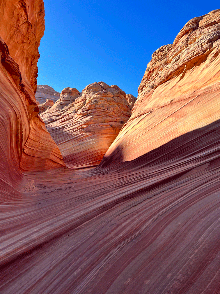
We walked down through “The Wave” to get this view.

We continued down and turned left into the cleft that is in shadow in the photo below.

We explored the area and walked about another five hundred metres until we came to a drop. We had a good look at the canyon below.

When we circled back, we also climbed up and along, which gave us this view of the toadstools. The one to the right of centre is the colourful toadstool that was in a previous photo.

In this view from higher up, “The Wave” is on the left side.

So when we returned again the light was slightly different and we were at a different angle so of course we took more photos.


More posing.

It was about 11:30 when we did our final walk down “The Wave.”


The photo below is the view that Wendy is capturing on her camera in the above photo.

And this was our final look at “The Wave” as we headed back.

Within a half an hour, we were down, through the sand dunes and up again on the slick rock. Here’s a view of “The Teepees,” some interesting rock formations that we could see from the route.

Our hike back to the trailhead was full of interesting scenery.


About a half hour from the trailhead we finally found a place to have lunch that was not too windy. We made it back to the truck around 2:00. It had only warmed up to 2 degrees C! Hot showers in our hotel in Page were next on our list.
We hope you have enjoyed our virtual tour of “The Wave.” It was a once in a lifetime experience for us.

Absolutely stunning. Thank you so much for sharing.
LikeLike
Great collection of photos of “The Wave” rock formations.
LikeLike
What a brilliant photo-essay. I shall go back and view this again as there is so much to absorb. Wonderful, thank you.
LikeLike